

| Introduction | ||||
|
||||
| Update History |
||||
|
||||
| Usage | ||||
| Untar, compile & execute it under the "util" directory of your Vis5D dir, it will generates a makemap.c file. First, please enter the input file name, and you'll be asked if you want to filter out data points or not. After choosing "y", you have to enter the criteria in degree (1.00 deg. approximately equal to 100km). Then enter the output file name, decide if you want to *MAKE and RUN automatically. In the end, select the debug level:
*Note: This feature needs to put the program into the "util" directory under vis5d's directory correctly. Note: Larger map file may slowdown the speed of Vis5D+, but it seems ok to Vis5D 5.x Note: If you encounter "Error: must call vertex() before end_line()!" while executing makemap, please try NOT to filter out data points, or delete that solely data manually, in "InputFileName_MOD". This error might be caused by only one point left after filtering. |
||||
| Licensing: | ||||
| This software is licensed under the Creative Commons-GNU GPL version 2.0 or later. |
 |
|||
| Download | Version | File size | File format | Released |
| Source Code Source Code |
2.0.0 1.0.0 |
4.55 KB 4.7 KB |
.tar.gz .tar.gz |
2012 Feb.10 2010 Sep.14 |
| Operating System: Linux Requirement: Fortran 90 compiler, C compiler and vis5d+1.2.0 or later version |
||||
| Contour Map download | File size | Released | Description | |
| Administration boundary of R.O.C Tawian |
600 KB |
2012 Feb.10 |
Administration boundary made from IOT data. | |
| *Taiwan |
13 KB | 2010 Sep.8 | This contour map was calibrated by myself (using satellite image) | |
| *EastAsia |
725KB | 2010 Sep.14 | TWN/JP/PH/SKR/NKR/CN/MN/VN/KH/TH/BN | |
| *Oceania |
1.08MB | 2010 Sep.8 | Au/NZ/ID/PNG...etc (about 30 regions) |
|
| *Note: File marked with asterisk are made by V1.0.0 and Maproom database, the database was developed in 1991/1992, there might be some errors in it. Users of Vis5D+: Put the map under /share/vis5d+/ of your Vis5D+. Add: -map OUTLTaiwan when executing Vis5D+. Users of Vis5D : You can put the map anywhere. Add: -map ./(DIR)/OUTLTaiwan when execution Vis5D. |
||||
| Output Example | ||||
Vis5D Built-in map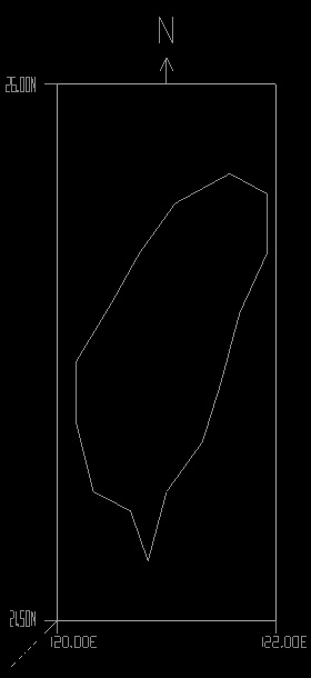 |
Using data form Maproom (Calibrated)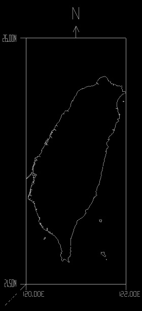 |
|||
| Input File Format (Reference for V1.0.0) |
||||
For those who intent to make their own maps:
|
||||

Copyright (c) 2010-2012 Cypresslin
