

MM5修改地形高度:
在進行數值實驗時,常常會藉由修改地形高度來檢驗一個天氣系統的變化,大概每一篇颱風模擬的Paper都會出現一個關於地形敏感度實驗的章節XD,以下內容出自我寫給學弟妹的MM5使用手冊:
MM5/TERRAIN的地形製作流程:
- 主程式terrain.F呼叫TERDRV(terdrv.F)
- 副程式terdrv.F將會根據所設定的網域大小,計算所需維度並讀入地形資料。
- 接著會呼叫CRLWMSK製作Land-Water mask,
該遮罩變數名稱為FORCETER,值9E9代表陸地,0.001代表水域。 - 接著程式它將會呼叫副程式CRTER來製作地形。
地形敏感度實驗:
倘若只是想要修改地形高度的話,可以由crter.F這個檔案下手,地形高度的變數名稱在這裡為HT,只要在return前寫個判斷式來修改某經緯度範圍內的HT即可(經緯度變數分別為XLON、XLAT)。以下是一個比較簡單的範例,為了向下相容所以用77的格式撰寫:| ! =========================================================================== ! = MM5 Terrain modification, ! = Insert me between "continue" (CRTER.171) and "return" (CRTER.174) ! = by Dennis and Cypresslin - http://cypresslin.web.fc2.com/ ! =========================================================================== | |
|
iActivate = 1 factor = 0.0 | ! 1 - yes; 0 - no ! multiplier, 0.0 - no terrain; 50.0 - 50% terrain ... etc |
|
if ( iActivate .eq. 1 ) then do j = 1,JX do i = 1,IX ! Specify the area you want to modify if ( XLAT(i,j) .gt. 21.5 .and. XLAT(i,j) .lt. 25.5 .and. & XLON(i,j) .gt. 119.95 .and. XLON(i,j) .lt. 122.02) then HT(i,j) = HT(i,j) * factor endif enddo enddo endif | |
以上程式碼會將一個方塊內的地形剷平,若if判斷式越詳盡,就越能處理不規則形狀的地形。
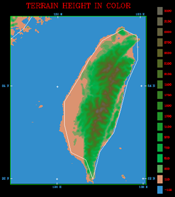
結果如下(Full terrain vs. No terrain):
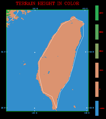
若要把地形整個挖掉變成海(Ocean Run):
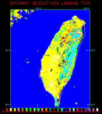
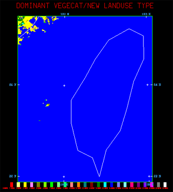
在修改了地形高度之後想修改地表分類的話,到crlwmsk.F裡面修改FORCETER這個陸地-水域遮罩變數將陸地的遮罩移除,讓它的地表分類變成海洋會比較直接,只要在CRLWMSK.175後加入範圍判斷式,將指定範圍內地形設定為水域0.001即可,如下:| ! =========================================================================== ! = MM5 Land-Water mask modification, ! = Insert me between "ENDIF" (CRLWMSK.175) and "ENDDO" (CRLWMSK.176) ! = by Cypresslin - http://cypresslin.web.fc2.com/ ! =========================================================================== iActivate = 1 if ( iActivate .eq. 1 ) then ! Specify the area you want to modify if ( XLAT(i,j) .gt. 21.5 .and. XLAT(i,j) .lt. 25.5 .and. & XLON(i,j) .gt. 119.95 .and. XLON(i,j) .lt. 122.02) then FORCETER(i,j) = 0.001 endif endif |
結果如下:
製作出TERRAIN_DOMAIN#之後,不要忘記先看看他的TER.PLT,或者是用MM5toGrADS之類的轉檔程式把TERRAIN_DOMAIN#轉出來修改後的檢查正確性。
Special thanks to: Dennis (NCU)
<-Memo

Copyright (c) 2010-2012 Cypresslin
